Part No.: 010-02406-10
Garmin Tread Navigation Device (010-02406-10)
Price36 540 ₴
GARMIN Tread satellite navigation
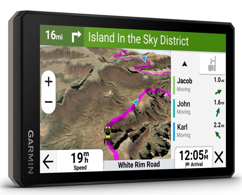
Head into the unknown! The Tread™ device is a rugged satellite navigator for motorsports fans. It is equipped with a 5.5-inch screen, the Group Ride Tracker group riding feature and factory-loaded topographic maps, ready for any off-road adventure.
The Tread™ navigator was created specifically for UTV, quad and snowmobile enthusiasts. That is why it copes excellently in extreme terrain, extreme temperatures and harsh weather conditions. Thanks to the function of tracking other group members, you can stay in constant contact with other participants of the trip, as well as share your location and send short messages to up to 20 other people, without requiring cellular signal access.
SCREENSHOT:
The navigator comes with preloaded topographic maps of Europe, the Middle East and Africa (including Tracks4Africa maps), and other regions are available for free download via Garmin Express. In addition, BirdsEye Satellite Imagery can also be installed on this device. The navigator can also be paired with an inReach® satellite communicator, which makes it possible to send two-way messages, receive weather notifications and send an interactive SOS signal.
GROUP RIDE FUNCTION RANGE:
Range depends on terrain and other line-of-sight limitations. Here are some examples of typical operation with the antenna mounting kit*
INCLUDED:
Tread™ navigator, VHF antenna, antenna mounting kit, pipe mounting kit, motorcycle handlebar mounting kit, high-current power cable, trim kit (blue, black, red and green), USB cable o
Head into the unknown! The Tread™ device is a rugged satellite navigator for motorsports fans. It is equipped with a 5.5-inch screen, the Group Ride Tracker group riding feature and factory-loaded topographic maps, ready for any off-road adventure.
The Tread™ navigator was created specifically for UTV, quad and snowmobile enthusiasts. That is why it copes excellently in extreme terrain, extreme temperatures and harsh weather conditions. Thanks to the function of tracking other group members, you can stay in constant contact with other participants of the trip, as well as share your location and send short messages to up to 20 other people, without requiring cellular signal access.
SCREENSHOT:
The navigator comes with preloaded topographic maps of Europe, the Middle East and Africa (including Tracks4Africa maps), and other regions are available for free download via Garmin Express. In addition, BirdsEye Satellite Imagery can also be installed on this device. The navigator can also be paired with an inReach® satellite communicator, which makes it possible to send two-way messages, receive weather notifications and send an interactive SOS signal.
GROUP RIDE FUNCTION RANGE:
Range depends on terrain and other line-of-sight limitations. Here are some examples of typical operation with the antenna mounting kit*
INCLUDED:
Tread™ navigator, VHF antenna, antenna mounting kit, pipe mounting kit, motorcycle handlebar mounting kit, high-current power cable, trim kit (blue, black, red and green), USB cable o
- Delivery across Ukraine via Nova Poshta or Ukrposhta
- Official distributor warranty
- 14-day returns
- Price excludes EU VAT. Ukrainian import duty/VAT (if the parcel exceeds the duty-free limit) is paid by the buyer on delivery
Similar products